
The seas and landscape retain tantalising evidence of our maritime past, whether through archaeological finds, place names or folklore. For centuries the coastline around Portrush has seen many visitors come and go.

Mesolithic adventurers made their way along the coast as indicated by the many flint artefacts that have been uncovered in and around Portrush. A number of Viking hoards have also been found and in the townland of Ballywillin there were reports of a clinker built boat discovered in a mound of earth that contained bones and silver coins.
The place name Portrush derives from Port Rois meaning ‘port of the promontory’ which makes reference to the harbour and the impressive promontory headland. “Porto Rosso” is named on the Portolan map below, which was created in Venice in 1468 to help guide merchant ships around our rocky coast. It is regarded as the oldest map of Ireland with Porto Rosso one of the 57 settlements identified on the map.

Looking out to sea from Portandhu on the East shore at Lansdowne you can see the Giants’ Causeway headland in the distance. Close to this lies the area known as Port na Spaniagh and Lacada Point. It was here on a stormy night in October 1588 that a ship called the Girona was wrecked while trying to make for Scotland. The Girona was part of the Spanish Armada, a fleet of ships that had set sail to assist in an attempt to invade England and overthrow Queen Elizabeth I. The ship was dashed to pieces on the rocks and it is believed that only five of the many hundreds of men on board survived.
In 1606 Sir Thomas Phillips was granted the customs of Portrush and remarked that Breton fishermen had been coming to Portrush for some time to fish for dogfish and rays, both of which were considered delicacies, especially in Spain.
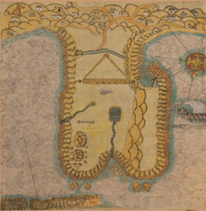
Sir Thomas Phillip’s 1611 map was prepared in support of his plan to fortify Portrush by digging a ditch to link the East and West strands.
The Skerries Roadstead is a sheltered stretch of water beside the chain of small islands, known as the Skerries, immediately off shore to the east of Portrush. It has provided a refuge for vessels escaping bad weather or needing an anchorage to take on cargo, crew or passengers and its proximity to the shore, and the depth of the channel, make it a safe haven for ships, large and small.

In 1630 a salmon fishing station is recorded at Portrush which was part of a thriving network of salmon fisheries along the north coast. The salmon trade continued into the 19th century with many ships calling into Portrush to restock for ice.
Early newspaper advertisements from the eighteenth century, advised prospective emigrants that their ship would leave Londonderry and then collect more passengers “from the Skerries Roadstead, off Portrush” before sailing for America. The emigrants would have embarked from the Pilgrim Steps in the harbour and would then be taken the short journey to their waiting ship by rowing boat. The earliest mention of emigrants leaving from Portrush that we have been able to find is for a Robert Morrison, born in Scotland c1684, who sailed from Port Rush on 7th August 1726 and ended up in Nottingham New Hampshire.

From the 1830s, passenger steamers would sail regularly to Portrush from ports such as Ardrossan, Ayr, Troon and Glasgow. During the summer season, the ships carried crowds of passengers who would disembark at the North Pier and enjoy the attractions of the coastal resort and surrounding landmarks.
Boat building was an important part of the town’s history with Kelly’s boat yard located at the East Strand. James Kelly produced many Drontheim boats which is the traditional wooden boat for the north and west coastal areas of Ireland and Scotland. It is a double ended clinker built boat, whose origins stretch back in time to the Viking influence.

In the early twentieth century, harbour business was badly affected by the upheaval of world wars. The decline continued as maritime freight and passenger vessels shifted to larger ports.
Today, Portrush is still very much a maritime town. The harbour is still the focal point of the town; the lifeboat is crewed by local men and women and it remains vital to the welfare of our mariners. The shoreline is crowded with surfers, swimmers, leisure boaters and there are thriving charter and watersports activities for sailors, anglers, marine tourists, sub-aqua divers, surfers and paddleboard enthusiasts.
As a designated Area of Special Scientific Interest, Portrush can be assured that it will be protected for generations to come.